# What file types can I upload to Civillo?
Civillo can upload multiple files to be used in your project. Here is a list of the file types you can expect to use.
All users of Civillo can upload geospatial files into Civillo, refer to the following links
- Administrators can upload files to share with all project members
- Normal users can upload files for personal viewing
# List of formats
# DWG
# AutoCAD Drawing File
DWG files are the native file format for Autodesk's AutoCAD® software. Civillo has been designed to use some of the AutoCAD Civil 3D features, including BIM designs and models, spatial reference systems, and object data.
Many AutoCAD objects are supported by the Civillo import process, some of these include:
| DIMENSION | LEADER | HATCH | OBJECT DATA* | REGION | CIRCLE |
| LINE | POLYLINE | ARC | POINT | MTEXT | MULTILEADER |
| SOLID | ELLIPSE | TEXT | 3DSOLID | LWPOLYLINE | MLINE |
| BODY | 3DFACE | SPLINE | SURFACE | BLOCKS | COGO points |
| PROPERTY SET** | |||||
*Object data is attribute data that is attached to individual objects and stored in tables in the drawing. Object data tables store text and numerical information related to an object - making the DWG closer to a traditional GIS format.
**Property Sets are attribute data that is attached to individual objects and stored in tables in the drawing. Property sets store attribute information related to an object - making the DWG closer to a traditional GIS format.
Civillo only supports manual properties with the Integer, Real, True/False and Text data types (including Auto Increment types). Please note that automatic and formula properties are not supported.
# DGN
# MicroStation Design File
DGN files are the native format for the MicroStation® construction design software application. The files can contain 2D or 3D drawings that are based on the V8 DGN standard.
# DXF
# AutoCAD Drawing Interchange Format
The DXF file format is the AutoCAD drawing exchange format that allows for interoperability of drawing files. The Civillo importation of DXF files supports the same objects as the DWG import.
# IFC
# Industry Foundation Classes
The geometric, IfcPropertySet and IfcElementQuantity components of an Industry Foundation Classes (IFC) data model can be imported into Civillo.
Currently supported IFC specifications are:
| IFC2X3 | IFC2X_FINAL | IFC4X1 | IFC4X2 |
| IFC4X3 | IFC4X3_RC1 | IFC4X3_RC2 | IFC4X3_RC3 |
Civillo imports the geometries of the subset IfcBuildingElement (opens new window).
For successful import of an IFC file, all geometries need to be coordinated on a known UTM datum.
# 12d
# 12d Archive File
The 12d model format can be imported into Civillo, either in .12da or .12daz format, by Civillo Administrators only (the same as imagery and terrain). Each 12d model as an extensible attributes that are imported into Civillo as per other import formats.
Note, all attributes are imported, including vertex_attribute_data if it has been included in the saved file. This vertex_attribute_data is very verbose (vertex_attribute_data is predominantly survey pickup metadata).
12d Models that are supported (and their sub-models) are:
| String / Super strings | Circle | Drainage | Primitive 3d (Trimesh) | Text |
| 4d | Arc | TIN | Super TIN | Super alignments |
Some 12d models are not supported, these include drawing_elements, pipeline and alignments (note super alignments are supported). Please contact info@civillo.com directly if these models are required.
TIP
Referring to the 12d documentation (opens new window) (Version 15, May 2022), null z-values should be replaced by the 12d Model null value (section 1.4.5).
# 12d Colors
Currently Civillo does support the importing of 12d .4d (opens new window) color files. These are configuration files that are specific to each 12d install.
To load the .4d file, select the 12da / 12daz with the 4d file when creating the layer.
Civillo supports standard named formats for colors which includes the standard AutoCAD colors 0 to 255, MicroStation colors and standard 12d named colors.
# SHP
# ESRI Shapefile Format
The Shapefile format (made up of 4 files), is an older style GIS format that was created by ESRI. Each shapefile can only contain one style of geometry - either (Multi)Points(Z), (Multi)Lines(Z), or (Mulit)Polygons(Z).
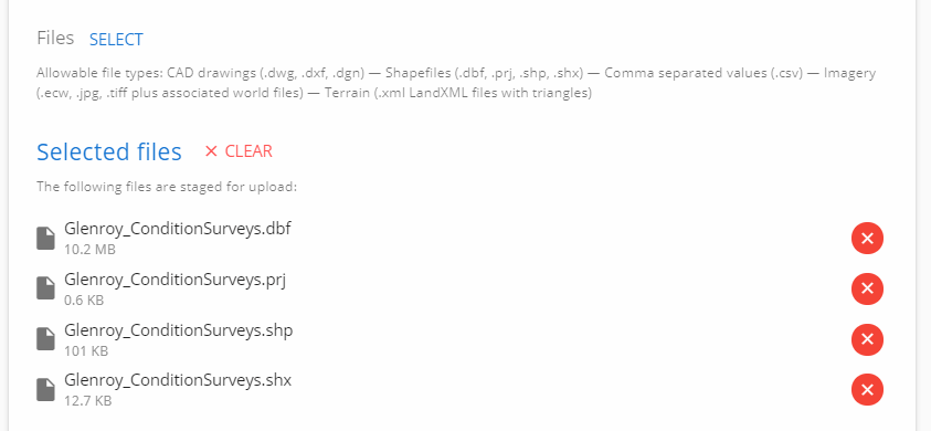
The 4 files that makeup a shapefile are:
- .shp - shape format, containing the feature geometry
- .shx - a spatial index of the feature geometries
- .dbf - attribute format, rows for each feature geometry, in dBase IV format
- .prj - the shapefile's coordinate and projection system
When importing a shapefile layer, all 4 files need to be selected for a successful import. Users can select a zip file that contains these 4 files, however they will be extracted from the zip before uploading. A zipped shapefile can only contain one set of files (.shp, shx, .dbf, .prj).
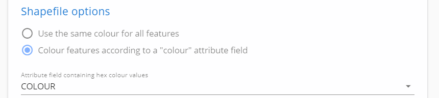
Unlike CAD files, Shapefiles do not contain any styling information, so Administrators will need to select either a uniform color for the shapefile geometries, or select an attribute that contains the color for each specific geometry in a hexadecimal color format (opens new window) (e.g. #FF00EE).
When uploading Shapefiles, Users can choose to ignore attributes they do not wish to import, by checking on or off next to the attribute's name.
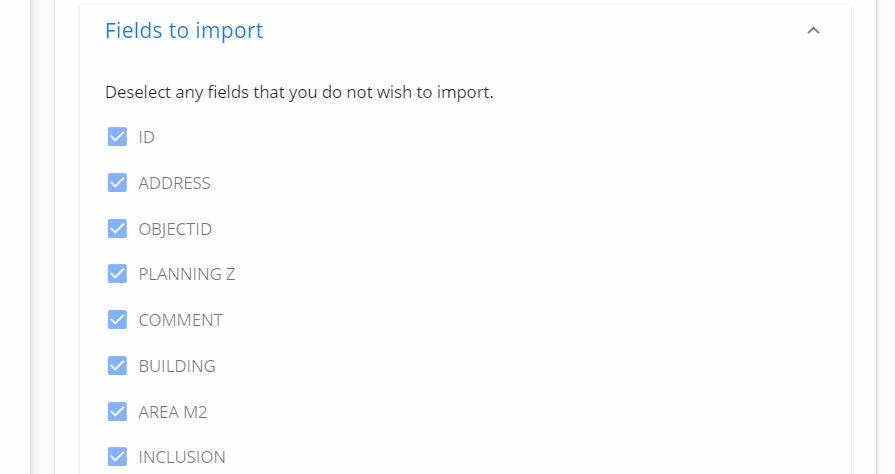
One limitation of the Shapefile format is that each attribute name is limited to 10 characters, so names are often truncated. E.g. an attribute with the name PLANNING_ZONES will become PLANNING_Z.
# CSV
# Tabular Data Stored in ASCII
Comma separated value, or CSV files are a ASCII text based columns and rows file. Currently the CSV import process only imports point geometries.
Columns are identified to nominate the X, Y and Z coordinates of the incoming point geometry.
For ease-of-import, column positions of 1,2,3,4 auto import as Label, Easting, Northing, Height.
Similar to the Shapefile import process, there is no color styling that is applied to CSV files, so users can nominate a color for the entire layer, or an attribute/column that contains a hexadecimal color code value (e.g. #FF00EE).
Importing CSV files also provide the option of adding a label to the point geometry. This label is taken from a field in the CSV, and supports adding line breaks using \n.
As an example, this CSV file:
Name,E,N,H,Color
Control\nCP1,320430.49,5820091.59,11.2,#FF00EE
will render with a line break like the following image:
# GDB
# ESRI File Geodatabase (vector only)
Geodatbases are a relational database storage format created by ArcGIS 10 and above, that consist of a directory of proprietary files. Each Geodatabase directory has a .gdb extension.
Geodatabase directories can be zipped and imported into Civillo, with the extension .gdb.zip.
Geodatabases can contain many Feature Classes within a database. Each of these Feature Classes are imported as Civillo sublayers, meaning all data in the Geodatabase will be toggled on / off from the Civillo layer.
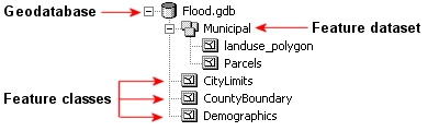
As Geodatabases can contain large amounts of data, Civillo restricts the import of each .gdb.zip to be 40MB.
Unlike the Shapefile import, a color attribute can not be detected until after the zipped directory has been uploaded. Therefore, each sublayer is assigned a random color that Administrators can change after import. Refer to editing sublayers to review how to adjust sublayer colors.
# GPKG
# GeoPackage (vector only)
GeoPackages are a non non-proprietary spatial relational database in a single file, with a .gpkg extension.
Like Geodatbases, the GeoPackage format can contain many tables within each file, and each table is imported as a Civillo sublayer. Each sublayer is assigned a random color that Administrators can change after import. Refer to editing sublayers to review how to adjust sublayer colors.
As GeoPackages can contain large amounts of data, Civillo restricts the import of each .gpkg to be 40MB.
Civillo will not import raster formats contained within GeoPackage files.
# LandXML
# Non-Proprietary XML Data Exchange Standard
LandXML is used to import terrain models and chainage alignments into Civillo. LandXML is a schema based document that defines civil and survey real-world objects.
Civillo supports LandXML versions 1.0, 1.1 and 1.2 (opens new window)
Civillo imports LandXML surfaces to support 3D terrains and LandXML alignments to support chainage alignments. More information on using LandXML is documented in the How to use terrain in 3D Civillo page and the Chainage alignments page.
# ECW
# Hexagon Enhanced Compression Wavelet
The Enhanced Compression Wavelet (ECW) format provides a raster format for use with geospatial data.
The advantage of ECW files is that they are a compressed format, meaning they are smaller to upload from your PC. Typically there is a 10:1 compression ratio from a GeoTiff raster to an ECW image.
# GeoTIFF / TFW
GeoTiff format is the most flexible format to use, and an open-source file standard. Typically GeoTiff's are one file with the georeferencing information written into the file header, however they are sometimes accompanied with a TFW file (a world file (opens new window)) of the same name.
# JPG / JPW
Individual JPG files, with their corresponding JPW file (a world file (opens new window)) can be imported.